In my last post, I wrote about what I was hoping to develop for my final project as a CHI Fellow. I planned to create a digital archive for materials associated with the historical Mt Pleasant Indian Industrial School. Instead, I will be building a web map that illustrates the spatial and temporal connections of one material type associated with the history of the Native American Boarding Schools: historical postcards. (Learn more about the history of postcards from this Smithsonian link.)
The Boarding Schools produced propaganda materials to inspire White communities to support their cause. I’d seen digitized versions of lantern slides, printed photographs, newspapers articles, etc., from several Boarding Schools (see Carlisle Indian Industrial School Digital Resource Center for examples) all used to drum up money and political support from White communities. I had not encountered postcards.
I am particularly interested in employing digital methods to recontextualizing material culture that has been extracted from its original context. Images and texts from the Boarding School period are circulated online, like in this New York Times web story, but these images and texts are typically removed from their historical context. This is important because the whole context of a historical object (past, present, future) is wrapped up in what that object is, and what it means to the communities who interact with it.
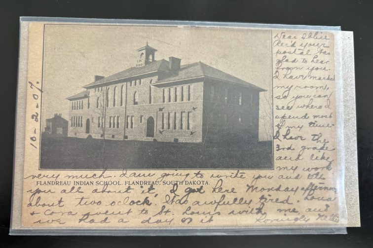
The postcards I have been collecting present an amazing opportunity for reconstructing historical context and relational interactions between people, places, and times. This is what my CHI project explores. While I first encountered the postcards at a later stage in their journey (on ebay, in used bookstores…), many of them contain an unexpectedly full record of times and places they’ve travelled: the photograph on the front of the postcard, printer company, the name of the sender and recipient, recipient’s address, and postmarks showing the mailing date and location. What’s interesting to me, is that the images showing Native American Boarding School buildings, grounds, and sometimes students, were travelling all over the country.
To explore the space travelled by images from the Boarding Schools, I am developing a web map. This map will help visualize how these images traveled around the country. While I do not have time to address this question during my CHI Fellowship, in the future I could also look at connections/lack of connections between the postcard text and images. So far, I have only encountered two postcards with text referencing the Boarding Schools. In one message, the writer notes how sad it is that the children at the school are not with their parents. In another message, on a postcard showing the Flandreau Indian School, the sender (Nellie) writes, “I have marked my room, so you can see where I spend most of my time. I have the 3rd grade and like my work very much. “
In order to build the website (featuring an interactive web map), I am working to become more proficient with Leaflet and GeoJSON. I will also be photographing the postcards in my collection, front and back, and displaying them on the map. Stay tuned!
*Note: On my website, I will not be showing images of the faces of children featured on the front of postcards at this time.
